情報連携学部(INIAD)では、障がい者や高齢者をはじめとした移動に制約を受ける人々を対象として、IoT技術とオープンデータを活用した移動支援プロジェクトに取り組んでいます。このプロジェクトは、身体属性などに応じた適切な情報提供を行うことで、まちを自由に移動できる環境を整備するもので、国土交通省と連携し、バリアフリーナビゲーションに必要なデータの整備を、行政だけでなく、ボランティアや利用者自身が参加し、お互いに助け合いながらデータの作成やメンテナンスを行う「オープンモビリティガイド・プラットフォーム」を構築しています。
INIADではその一環として、ICT(情報通信技術)を使ったバリアフリーマップの作成に1学年400名全員が毎年参画しています。
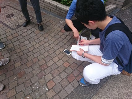
学生たちは、事前に地理情報システムや歩行空間ネットワークデータなどを使ってデータ作成の準備を行い、フィールドワークではスマートフォンアプリを用いた勾配の計測や、360度写真を活用して歩行者のいない写真を撮影。事前調査とフィールドワークで得た情報を照らし合わせ、データ作成作業の改善案や歩行空間ネットワークデータへの提案を行います。
これらの取り組みをさらに発展させ、地域そして社会のユニバーサルデザイン化に貢献することを目指しています。
The Faculty of Information Networking for Innovation and Design (INIAD) has implemented a project to facilitate the movement of people with restricted mobility, including people with disabilities and senior citizens, using IoT technology and open data. This project is aimed at creating a favorable environment for such people to move around the streets freely by providing them with appropriate information based on their physical traits and other factors. In collaboration with the Ministry of Land, Infrastructure, Transport, and Tourism, INIAD built an Open Mobility Guide Platform, where not only government officials but also volunteers and users themselves cooperate in data creation and maintenance to accumulate data necessary for accessibility navigation.
As part of the project, every year, all 400 INIAD students in the same year of study participate in creating accessibility maps using information and communication technology (ICT).
Before creating the maps, the students prepare for data creation using geographic information systems and data from the spatial network system for pedestrians, etc., and conduct fieldwork, measuring inclines with a mobile app and taking photos of streets devoid of pedestrians using a 360-degree camera. They then compare the data they obtained during the preparation with fieldwork data, and propose improvements in data creation work and data from the spatial network system for pedestrians.
INIAD aims to further evolve these initiatives and contribute to increasing accessibility of the region as well as society.